Sun&Moon
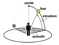
Sun&Moon plots the Sun's (or Moon's) current path in the sky for your location. The position is shown with two rings representing the azimuth and elevation. The animation below is a time lapse (the Sun's position barely changes in real time).

The outer ring (azimuth) is the horizontal angle away from due North. The inner ring (elevation) is the vertical angle above or below the horizon.

Both rings have two nodes: red for sunrise, black for sunset. They're like "holes": the Sun "pops out" of the sunrise node and "falls into" the sunset one. On the inner ring, a horizon line connects the sunrise and sunset nodes. It shifts up and down during the year, as daylight hours change.
Features
 |
Source and visual plugin
|
 |
Input plugin
|
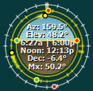
The rings
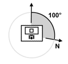
The azimuth ring can be rotated so that the top of the graph points to a direction other than North, e.g. the direction you face when you're in front of your PC. This lets you align the graph to your surroundings. If you do this, the Sun marker on the azimuth ring will point in the direction of the real Sun.

The inner ring is like looking south at the Sun's path above and below the horizon. The graph is always a circle, it won't "flatten" during the year like the real Sun's path. That's because I needed room inside the graph for the text info.
Settings
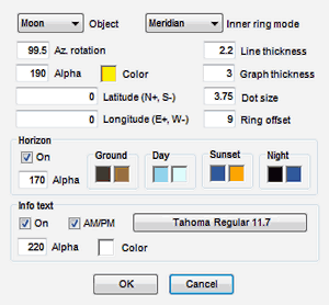
| Inner ring mode | Orients the inner ring w/r to clock time. Meridian puts the transit time (highest elevation) at the top (the "12 o'clock" point). This makes the rise and set points roughly symmetrical, and the horizon level. 24 hr clock puts 12 PM noon at the top and midnight at the bottom. The rise and set points will be asymmetrical, the horizon will slant. The slant is small for the Sun. For the Moon, the horizon can be at any angle. (*) |
| Azimuth rotation | Orients the azimuth ring by rotating the North point. |
| Graph thickness | The size of the tick marks on each ring. |
| Ring offset | The distance between the outer and the inner rings. |
| Horizon | Draws a horizon inside the graph. The colors change during the day. You can replace it with a panorama of your city :) |
| Info text | The text inside the graph, which shows the Sun's current azimuth, elevation, sunrise, sunset, solar noon, declination, and today's highest elevation (or similar info for the Moon). |
(*) Moonrises/moonsets are not as "neat" as sunrises/sunsets. They're not symmetrical w/r to noon and they shift each day by about 50 min. On a given day, a moonrise or a moonset may not occur at all. On such a day, the inner ring will switch to 24 hr clock mode if it's set to Meridian. The affected node and time won't be shown. A moonset may occur before moonrise.
Astronomy notes
Solar noon is when the Sun is at its highest in the sky. It coincides with clock noon (12 PM) only 4 times in a year. Otherwise the solar noon drifts back and forth by up to 16 min. The culprit is the elliptical shape of Earth's orbit. Your distance from the central meridian of your time zone also shifts the solar noon, up to ~30 min either way. DST can add 1 hr of additional shift. The time of the Moon's transit (highest elevation) has no relation to clock time at all.
The apparent sunrise is when the top of the solar disc shows up above a flat horizon. This happens before the elevation of the Sun flips from negative to positive values. That's because 1) the Sun's disc has a sizeable dimension (0.5°) and 2) the air is refractive: it "pulls" the Sun's image up from under the horizon. The sunset's case is analogous, but in reverse.
Sun&Moon's rise and set times may differ from what you find online for your city. That's because Sun&Moon uses equations to actually compute these times for your specific coordinates, down to street level. In contrast, the values you find online are taken from tables computed for your city's airport, university, etc. In a big city, the difference may add up to a few minutes.
Coordinates
See Wikipedia article on how to obtain precise coordinates.
Source plugin tags
| [sunazim] [sunelev] [sundec] [sunhel] [sunlel] [sunrisesh] [sunrise] [sunsetaz] [sunnoon] |
[sunset] [daylen] [sunriseaz] [sundecD] [sunriseD] [sunnoonD] [sunsetD] [daylenD] [sunriseshD] |
[sunhelD] [sunriseazD] [sunsetazD] [moonazim] [moonelev] [moonrise] [moonset] [moontrans] [moonhel] |
[moonriseaz] [moonsetaz] [moonphase] [lastfull] [nextfull] [moondist] [moonlun] [moonage] |
| ...D | Delta: the difference between today and yesterday |
| sunrisesh | How much today's sunrise azimuth deviates from due East |
| sunnoon | The time of the solar noon |
| sunhel | Today's highest elevation of the Sun (angle in deg.) |
| sunlel | Today's lowest elevation of the Sun (angle in deg.) |
| moontrans | The time of the Moon's transit (highest elevation) |
| moonhel | Today's highest elevation of the Moon |
| moonphase | Moon's phase spelled out: "Full", "Gibbous", etc. |
| lastfull | The date of the last full moon (mm/dd/yy). |
| nextfull | The date of the next full moon (mm/dd/yy). |
| moondist | Current Earth-Moon distance (363,300—405,500 km) |
| moonlun | Lunation period expressed as a fraction: from 0.0 at new moon, through 0.5 at full moon, to 1.0 at the next new moon. |
| moonage | Lunation period expressed in days (part of a synodic month) |
Download
Download SunMoon_1.2.zip (41K)